The Tolicha Peak Electronic Combat Range (TPECR) is a substantial, but little known facility of the Nellis Complex. It's located on Pahute Mesa, about 3 miles northeast of Tolicha Peak, and about 2 miles north and slightly west of Quartz Mountain. It is at least 20 miles south of the southerly boundary of the Tonopah Test Range.
|
Main access to the facility is via a paved road from Highway 95. The intersection of this access is about 20 miles north of the town of Beatty. There are no signs on the access, but after about 2 miles a guard house is reached, blocking further travel.
The only known viewpoint is about 18 miles away to the north, from any of a number of spots in the Stonewall Peak area. Of course, another alternative is from the air, since this facility is beneath that portion of airspace whose restriction was recently changed to weekdays only. A Sunday morning overflight is a distinct possibility.
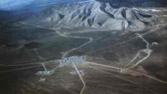
The view from the Stonewall Peak area reveals this to be an installation of considerable size, spread out over several square miles. The facilities are located out on Pahute Mesa and on the alluvial fans out away from the surrounding mountains. The main complex has a number of structures, including what appear to be 2 hangars, but they may also be warehouse or workshop structures. There were no obvious signs of a landing strip. To the north of the main complex, there was another interesting installation with some sort of long antenna array, laid out in an east/west direction. There were several other outlying facilities, consisting of at least a few sizable buildings each.
The Nellis range chart (a map of the airspace of the Nellis Complex for military pilots) shows a rectangular zone of airspace over this facility labeled, not surprisingly, "TPECR". The map also shows two semicircular bulges on the north boundary of the TPECR box labeled "FAC ALPHA" and "FAC BRAVO". Just how these areas relate to ground installations is as yet unclear, but at least one of them should be over the previously mentioned array area.
Presumably from the name, the facility is involved in electronic combat operations involving aircraft. Some Tonopah Test Range documents refer to a "Tonopah Electronic Combat Range". It is unclear whether that is another name for this facility, an entirely different facility, or if this facility is just a component of an overall Tonopah Electronic Combat Range.
It is uncertain just how long this facility has been in operation. A review of the Landsat "Pahute Mesa"; 1:100,000 image, published by the USGS in 1984, suggests if the facility was there at that time, it was considerably smaller, although the limited resolution of the image makes positive identification difficult. If the facility is one that has either been built or greatly expanded in recent years, it may be the source of the stories, most often put forth by John Lear, that the alleged discs of Papoose Lake have been moved to Pahute Mesa. Thus a perfectly mundane, although secret, facility could have generated some pretty outlandish stories.