Since Google offered the "Google Earth" application, expectedly lots of people found "anomalies" of all kinds in all sorts of places.
|
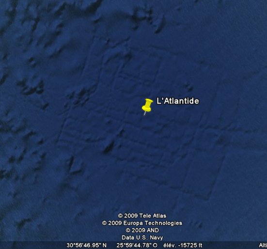
One of the latest such "anomaly" was found in the beginning of 2009 and was claimed on several web forums, then on some "UFO websites", the in the French sensationalist magazine "Top Secret" for April-May 2009, to be the ruins of Atlantis visible at 31° 20' 53,76" N 24° 20' 44,21" W in the Atlantic Ocean:
|
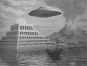
The so-called anomaly or "ruins of Atlantis" was quickly explained by ufologists, it was also explained by the Google Earth responsible person, but little people knew that, little people made any effort to check it out, and others of course claimed the explanation is a "conspiracy to hide the truth" and as this pseudo-discovery lived on and was propagated on French-speaking lists, by amateurs and also by incompetent ufologists, sometimes with the old boring and silly claim that "saucers come from Atlantis", so I think it was worth to display what this really was.
Steve Miller, product manager for Ocean in Google Earth, explained it via the website of the New York Times, see:
Quite simply, some data supposed to show the ocean floor were from satellites, but the map was fused with other data, from a ship. The ship mapped a grid of lines, and made more accurate measurements than the previous one, thus slightly different. Google merged the two kinds of measurement maps, and that's how the artifact was created, giving the impression Atlantis appeared!
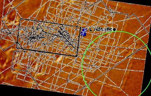
One diligent British ufologist soon identified the very document about this geological measurement operation:
Available at:
http://eprints.soton.ac.uk/15118/01/250.PDF
Figure 3a on page 54 shows the chart of the ship tracks followed during sidescan sonar bathymetry over this exact area during a major UK study to assess the suitability of the seabed in this region for disposal of nuclear waste.
It shows that the ship's tracks is the same, and at exactly the same place, as the patterns on Google Earth.
Another ufologist from the US took care to use this chart and scale it and surimpose it to the google map and it showed totally showed the match.
As the ship tracks map shows the actual ship tracks and not necessarily only the passes when it made measurements there are of course a confusingly higher number of lines on the ship tracks map than on the so-called "Atlantis". But the match is clear.
I did this too:
|
In France too, someone provided the correct explanation, in May 2005, as he got it from his son who lived in the Canary Islands and knew what the anomaly really was.
Clase closed!
Except for some die hard lunatics of course. Let them not fool you. Some people, always the same few ones (*), never accept any explanation whatsoever and do not realize how much they ridicule themselves with their silly claims and inability to understand or reason.
(*) After I pointed the explanation, one of them put out this highly intellectual argument: "PFFFFFFFFFFFF!", and another demonstrated he understood nothing by arguing that "sonars don't dig trenches on the sea floor"!